Markers – The River's Memory Book
One of the joys of walking the Thames Path is that there is always something new to discover. Some treasures leap out at you – historic bridges, lock cottages, colourful narrowboats and sweeping riverside views. Others are far easier to miss. Next time you're walking beside the river, look a little closer at lock walls, bridge supports and riverside buildings. You may spot a small metal plaque marking a date and a water level. It might not seem particularly exciting at first glance, but these modest signs tell some of the most dramatic stories on the entire Thames.
Flood markers are the river's memory book. They record the highest water levels reached during major floods, preserving moments when the Thames transformed from a gentle companion into a powerful force of nature.
What Exactly Is a Flood Marker?
Flood markers are plaques, signs or engraved marks installed to show how high floodwaters rose during significant flooding events. Some date back more than a century, while others record more recent floods. Standing beside one can be surprisingly striking. A marker positioned above your head quickly brings home just how much water once filled the space around you. Suddenly the tranquil riverside path you're standing on becomes something very different. The towpath disappears beneath murky water. Meadows become lakes. Roads become waterways. These markers help us understand that flooding has always been part of the Thames' story.
Why They Matter
Flood markers do more than record measurements. They tell stories of communities living alongside the river for generations. They remind us of the lock keepers, boatmen, farmers and families who experienced these floods first-hand. They also help explain why so much of the Thames Valley remains open floodplain. Those wide meadows that walkers enjoy today perform an important function, providing space for floodwater when river levels rise. Without these natural floodplains, communities further downstream would face even greater flood risks.
Reading the Landscape
Once you start noticing flood markers, you'll begin to understand the Thames landscape in a completely different way. Walkers often wonder why some sections of the Thames Path become muddy or flooded after heavy rain. The answer lies in the river's long history of overflowing into its floodplain. These signs provide visible evidence of where the water has reached in the past, helping us appreciate the dynamic relationship between the river and the land around it.
More Than a Historical Curiosity
Flood markers aren't simply relics of the past.
Many locations now display markers from different periods, allowing visitors to compare flood events across decades or even centuries. They provide fascinating evidence of how the river has behaved through changing weather patterns and changing land use.
For walkers interested in local history, environmental heritage or simply unusual things to spot along the trail, they offer a unique connection to the Thames' past.
A Flood Marker Treasure Hunt
On your next Thames Path walk, keep an eye out around:
-
Lock buildings
-
Lock gates and walls
-
Bridges
-
Weirs
-
Historic riverside buildings
-
Stone boundary walls
You may be surprised how many you find. Please be cautious near the waters edge, and never enter the water.
And once you've spotted your first flood marker, you'll find yourself looking for them everywhere.
In our next blog, we'll visit some of the best places along the Thames Path to discover these fascinating reminders of the river's power.
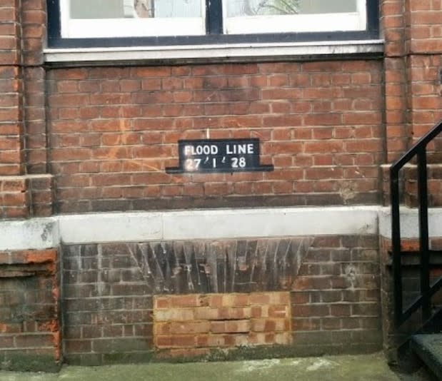
Below is an image of the flood marker on the wall of the Tate Britain, London, showing the height of a flood from January 1928.